
Christmas lights were going up when we arrived at cottage number two in Page’s Resort on Gabriola Island. High tides, arctic air, bufflehead ducks, four o’clock sunsets – signs that winter is well on its way. Our plan: bundle up, mind the tide tables, and enjoy a week’s worth of walks on this close-to-home Gulf Island, just a twenty-minute ferry ride from downtown Nanaimo. With trails along sandy beaches, sandstone shelves, headlands, country roads, and old-growth forest, Gabriola Island is a great choice for walkers and photographers, too.
Gabriola Island (map) is not very big – just 14 km long by 4 km wide – but it is blessed with an abundance of parks and trails, and walkers are welcome here. Gabriola boasts three provincial parks, two regional parks, and twenty-seven community parks, six of which are waterfront. Twenty-five walks are documented by the Gabriola Land and Trails Trust, and we tackled them all during our one-week visit. Maps and walks descriptions can be found at the GaLTT website, but here are our personal observations:
Prettiest path: Drumbeg Provincial Park, where groomed trails meander through Garry oak and open meadows and along sandstone shoreline, with views of Gabriola Passage, the Strait of Georgia, and the Coast Mountains on the mainland.
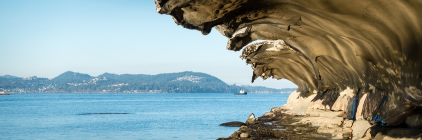
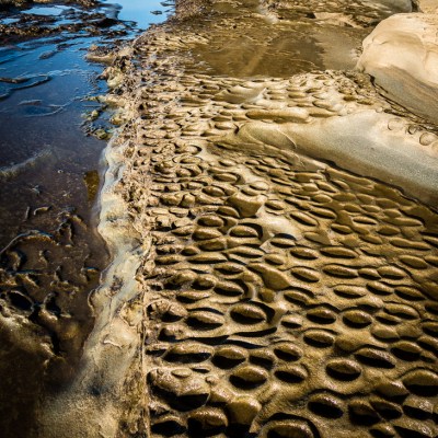
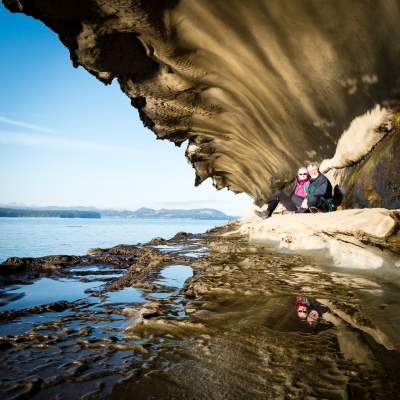
Best sandstone sculpture: Malaspina Galleries, where a spectacular limestone cavern has been carved by wind, waves, and salt spray. A magical must-see.

An interesting isthmus: Gabriola Sands Provincial Park, which spans two beaches on either side of a narrow neck of land. The twin bays, Taylor and Pilot, provide shelter for shorebirds.
Best walk that is almost a hike: The trail that follows the top of the bank east from Whalebone Beach to Elder Cedar Nature Reserve. Choose from several interior trails to make this a loop.

Best place to practice navigation skills: 707 Community Park, a recently-logged forest in the centre of the island. The original logging roads and footpaths are in the process of being marked, but it’s easy to get lost in this 707-acre park. Highlights: getting lost and found, arbutus groves, and frost-flocked firs.

Best little loop on country roads: Clarendon-Upper Berry Point loop. After navigating shoreline, country roads, and a narrow trail past sheep farms and apple orchards, this route emerges at Orlebar Point to view Entrance Island, with one of the last manned lighthouses on the British Columbia coast.
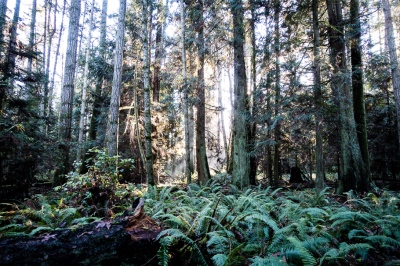
Biggest trees: Elder Cedar Nature Reserve. This forest walk follows a creek through the island’s last remaining stand of old-growth trees and some rare species.
Best ice crystals: Sandwell Provincial Park, where frost-covered logs line the long sandy beach.
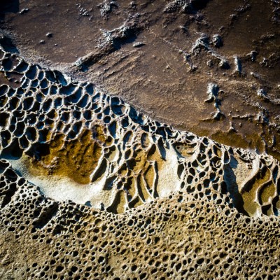
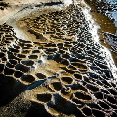
Best on a wet morning: Petroglyph Trail Loop. More than fifty petroglyphs have been discovered in the surface of moss-covered sandstone. These rock carvings are most visible after a rain.
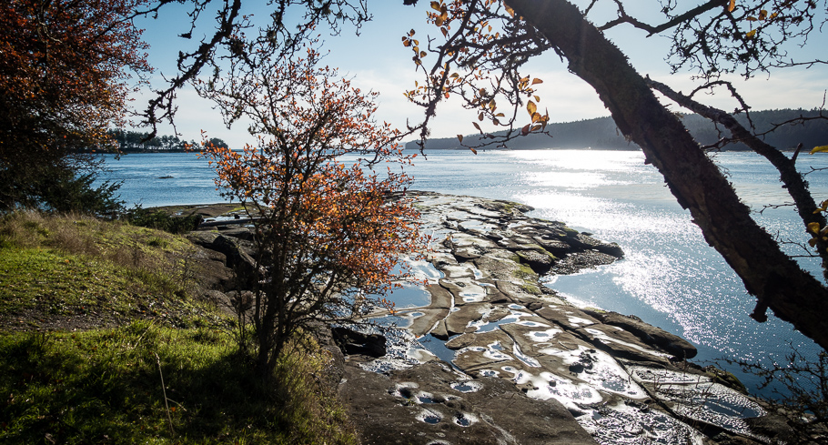
Sunniest trail: False Narrows Shoreline Trail, a great place to observe tidal action and herons feeding at low tide. The tidal flow in the narrows can be so strong that it runs like a river! This south-facing trail ends at Brickyard Beach, where bricks were manufactured during the depression years.
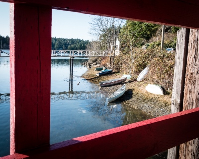
Noisiest pigeons: Degnen Bay government wharf. This historic harbour serves commercial and pleasure vessels – and pigeons.
When the sun set each day, it was time to return to our cottage, light a fire, and plan our evening entertainment: popcorn and downloaded movies. In his spare time, Doug has been revising the format of our blog-site; have you noticed a difference?
We fell in love with our secluded seaside cottage at Page’s Resort and Marina. What began as a fish camp in the early 1940s has evolved into a welcoming resort, campground, and full-service marina. Our cottage had just the right mix of charm and comfort, with a seasonal centrepiece for Cathy to enjoy, and a Bah Humbug pillow for Doug. It’s beginning to look a lot like Christmas. Dear readers, Seasons Greetings to you all!

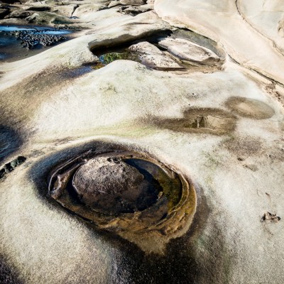
An enjoyable read and a clever layout of photos (the closing shot, using the reflection and looming sandstone, must have taken a fair amount of time).
LikeLike
Thanks George. The closing shot with the reflection was actually an accident. We didn’t even know the reflection was there until viewing the photo later in Lightroom. We just about fell over when we saw it.
LikeLike
Wonderful photography, as usual (love the frosty logs!). Good to hear about the trails and beauty of Gabriola Island. Though I’ve been there briefly a couple of times, your write-up makes me want to go for an extended visit, as you did. Thanks, Cathy and Doug.
LikeLike
Thanks for your kind words, Laura. Gabriola has a very welcoming feeling to it. Several locals stopped us to see if we needed help finding our way. Guess we looked lost, as usual.
LikeLike
I just sent you a text that I hope you received. I don’t use facebook, twitter or other really complicated things like that
LikeLike
We did receive a text message on our phone, but didn’t know who it was from (’til now). I’ll send you an email with answers. I hope I have your correct email address.
LikeLike